This is an AI-prepared desktop source check for a community question about gardens, watersheds, and rainwater in Duluth. The provider offer request asks for a bounded, reproducible screening before anyone proposes a paid report. No garden organizer has agreed to a site study, and no provider has been selected.
One reproducible map check
The Duluth Community Garden Program's location page embeds a public KML map of garden markers. On 2026-09-28, its Chester Creek Community Garden marker was at longitude -92.0899378, latitude 46.807297. This is a map point supplied by the garden program, not a surveyed garden boundary or confirmation of current site operations.
An intersection query of that point against Minnesota DNR's catchment layer returned one feature: catchment 0204000, named “City of Duluth-Frontal Lake Superior,” with a ver_date value of 10/31/2023. The layer is DNR Watersheds - DNR Level 08 - All Catchments, originated by the Minnesota DNR Division of Ecological and Water Resources, Watershed Delineation Project; its published metadata gives publication date 11/01/2023 and attribution requirements. This locates the program's marker in a mapped broad catchment. It does not show which nearby surface, pipe, or roof drains toward the garden.
A terrain window available without City GIS access
On 2026-10-04, an AI-prepared extraction read a 400 by 400 metre window around the same marker from MnGeo's Statewide Seamless 0.5m Lidar DEM, Minnesota, 2025. The second-generation lidar access page provides public raster access independently of the City's GIS login. The catalog item `dem_5_51_m` identifies the source Cloud Optimized GeoTIFF. Reading only its window avoids downloading the advertised 54.85 GiB tile.
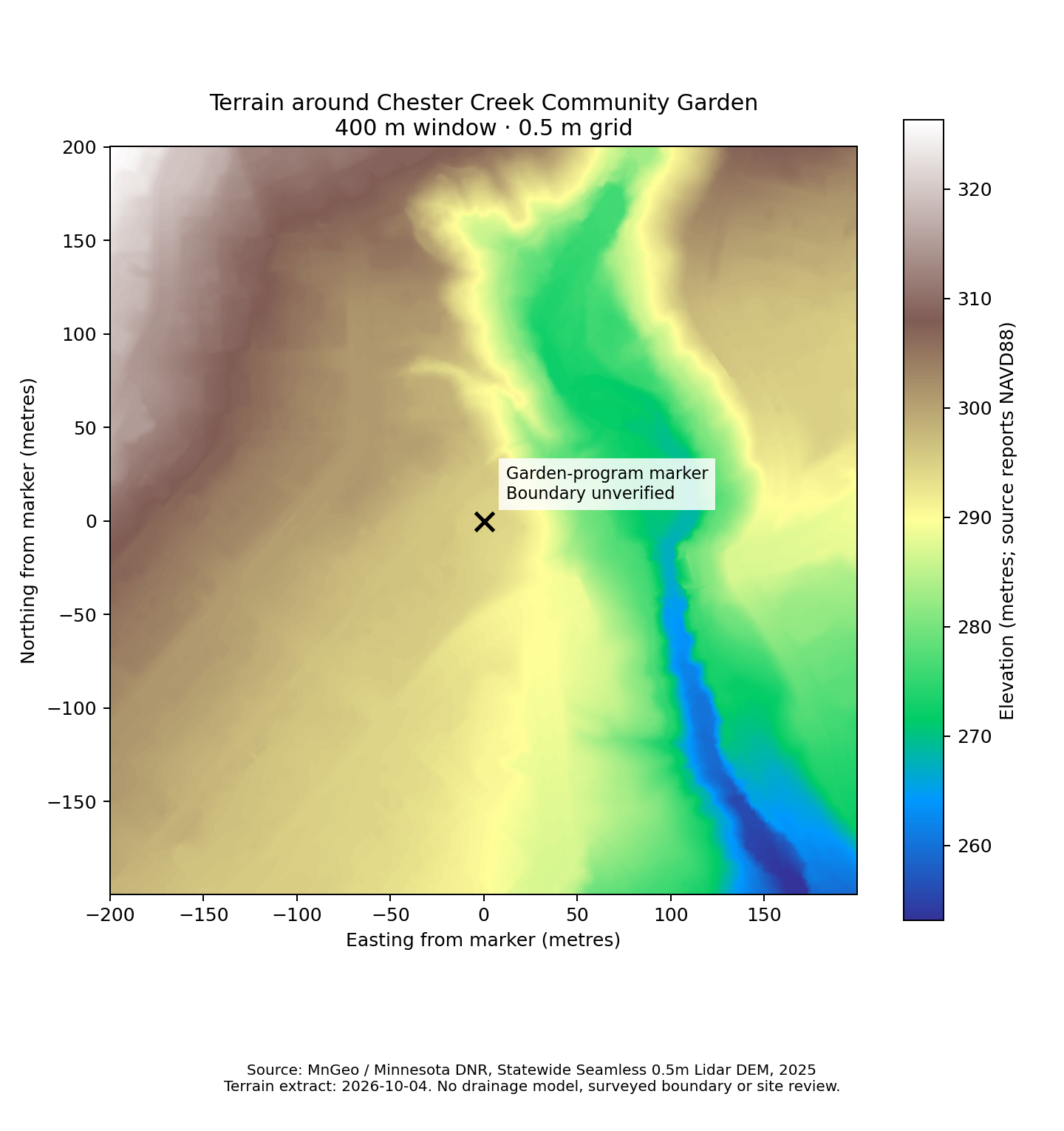
The saved extract contains 800 by 800 cells at the native 0.5 metre spacing, with 640,000 valid cells and no missing cells. Its elevation range is 253.13–326.32 metres. The raster's horizontal reference is NAD83(2011) / UTM zone 15N, and its vertical reference is NAVD88, in metres. The catalog reports Geoid09 and a publication date of 2025-11-24; that date is not a verified acquisition date for this garden. The figure shows lower ground east of the marker within this window. That is a terrain observation, not evidence that any roof, road, pipe, or garden drains along a particular route.
Download the small GeoTIFF, source catalog response, extraction metadata and Python reproducer directly from this site. Open terrain.tif in a GIS application to examine the same cells. To make another extract, install Python with rasterio, pyproj, numpy and matplotlib, then run python extract-terrain.py OUTPUT_DIRECTORY. extraction.json records the exact raster window, bounds, software versions, source links and SHA-256 hashes. Repeating against a changed source can give a different result; the saved extract preserves this observation.
Source credit: Minnesota Geospatial Information Office and Minnesota Department of Natural Resources, Statewide Seamless 0.5m Lidar DEM, Minnesota, 2025. This derivative clips the raster and renders an elevation figure; it makes no elevation corrections or drainage simulation. MnGeo's distribution statement describes source limitations, absence of warranty, and redistribution conditions. Grid spacing is not a claim of site-specific survey accuracy.
Precipitation-frequency context for the same marker
On 2026-10-04, the NOAA point query returned NOAA Atlas 14 Volume 8 Version 2 estimates for latitude 46.807297, longitude -92.0899378. The saved complete CSV retains the source's metric precipitation depths, partial-duration series, all durations and recurrence intervals, 90% confidence bounds and retrieval time. These four entries illustrate the table; they do not select a design storm for a garden.
| Duration | Average recurrence interval | Estimated depth | Source's 90% confidence bounds |
|---|---|---|---|
| 60 minutes | 2 years | 30 mm | 24–37 mm |
| 60 minutes | 10 years | 44 mm | 35–55 mm |
| 24 hours | 2 years | 68 mm | 57–80 mm |
| 24 hours | 10 years | 100 mm | 84–119 mm |
NOAA's frequency definitions distinguish partial-duration average recurrence intervals from annual-maximum annual exceedance probabilities. A recurrence interval is an average between qualifying events, not a calendar schedule. The confidence bounds describe uncertainty in the frequency estimate, not the range of depths in the next storm. Neither the estimate nor its bounds describe an observed storm at this garden.
Source credit: Perica and colleagues (2013), NOAA Atlas 14, Volume 8, Version 2.0: Precipitation-Frequency Atlas of the United States, Midwestern States, NOAA National Weather Service. Repeat the linked point query to retrieve a current response. This historical frequency product is context for a local question; it supplies no drainage route, contributing area, soil infiltration, runoff volume, future-climate projection, or site sizing decision.
What a useful drainage screening still needs
The City has a completed stormwater management plan covering watershed and sewershed characteristics. Its newer GIS service directory lists watershed, elevation, and storm-system folders, but unauthenticated queries to those folders returned Token Required on 2026-09-28. An older City utility map service responded publicly and lists storm-system layers; its currency, completeness, terms, and fitness for this question have not been established. A provider should verify current imagery, garden boundaries, storm infrastructure, local flow paths, and the City's relevant plan findings before interpreting upstream relationships. The terrain window above supplies an accessible elevation starting point; it does not supply those other facts.
A catchment intersection is not a surface-flow model, hydrologic review, water-volume estimate, or permission to redirect runoff. The actual drainage path, utilities, ownership, site conditions, and potential harm require appropriate field and professional review before any intervention is considered.
Evidence and next decision
- Evidence state: one reproducible catchment intersection, a saved terrain extract with a figure, and a saved NOAA point-frequency estimate with its uncertainty bounds. No completed drainage simulation, human source review, field observation, trial, or witnessed adaptation outcome.
- Vault work: the source check in `#receipts` and specific human review request in `#archive-desk` link to this record. A request for review is not a completed human review.
- Work selection: offers are open for a bounded feasibility slice. That request does not award work or authorize spending.
- Public use: this record uses public source material and paraphrases the question. It does not republish a member's Discord words or treat a Discord post as consent.
To improve it, join Turntide and bring a source or a general observation to #question-quarry. A steward must ask separately before publishing a member's words or a site-specific observation.